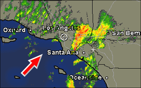
Earlier this week, I wrote a post about how the weather forecasters usually do a great job but, regarding the storms that have affected Southern California this past week, they didn't have much of a clue. The above radar map, which is from about fifteen minutes ago, is a good example of how capricious this can be. The red arrow, which I added, shows the approximate direction in which all this weather is moving.
We are presently under a Severe Thunderstorm Watch in Los Angeles — where at the moment, it isn't even drizzling, let alone thunderstorming. We had a lot of rain overnight (a lot for us) but it's been pretty much light showers for most of the day.
That's here. As you can see, there's been a ton of stormy weather moving through Long Beach and into the area just east of L.A. The red dots represent the most intense storms, the orange are close runners-up and the yellow is moderate rain. We have a little cell of possible light showers — indicated by the green — about to move through parts of L.A.
That Severe Thunderstorm Watch isn't wrong. It's just wrong for right this minute in right this area. The folks at the National Weather Service don't predict for your block and even if they did…well, take a look. A couple good gusts of wind and all those warm colored dots could have been over us here at the moment or even down in Oceanside. It's too much a crapshoot out there for them to know precisely where all this weather is going to go. We could still get lightning 'n' thunder later this evening.
People often moan that the forecasts are wrong, ignoring that the forecast was correct for most of the covered area. The N.W.S. and the private meteorologists do get it wrong, of course. They say it's going to rain and then there isn't a storm within a thousand miles of you. But sometimes — most of the time when the forecast seems to be wrong — what's happening is that the forecast is right for the area it covers. It just isn't right for the part of it that you're in at the moment.